2027 Pedestrian Safety Projects

Submit Your Feedback
The City of Cleveland is currently accepting comments for this project. All comments will be considered and receive a response, however those received by October 31, 2026, will be formally documented. Please use the comment form near the bottom of this page to submit your online comment.
The City of Cleveland received safety funding from the Ohio Department of Transportation to construct pedestrian safety treatments at 18 locations across the city. These locations were identified to address traffic safety concerns and make it safer and more comfortable for people to cross the street. Locations were targeted near community destinations such as recreation centers, libraries, parks, and schools. This project also supports our Vision Zero commitment to eliminate traffic crashes that result in fatal and serious injuries.
Where will these pedestrian safety treatments be installed?
The project includes 18 locations across Cleveland. Click the Council Wards below for a brief overview of the project locations.
Visit the 2027 Systemic Pedestrian Safety Project Locations Map to learn more about the specific pedestrian safety improvements proposed at each location. Please note: The specific safety treatments at each location are still being developed and may change as design progresses.
- Miles Avenue and E. 151st Street
- Kinsman Road and Griswold Avenue
- Kinsman Road between E. 71st Street and E. 75th Street
- Quincy Avenue and E. 40th Street
- Quincy Avenue and E. 55th Street
- Bridge Avenue and W. 44th Street
- Detroit Avenue and W. 26th Street
- Lakeside Avenue and East Mall Drive
- Lakeside Avenue and West Mall Drive
- St. Clair Avenue and East Mall Drive
- St. Clair Avenue and West Mall Drive
- Waterloo Road and E. 162nd Street
- Lakeshore Boulevard between Grovewood Avenue and Glencoe Road
- Arlis Avenue and W. 140th Street
- Lorain Avenue and W. 147th Street
- Rocky River Drive and West Park Road
- Rocky River Drive and Oxford Avenue
- Rocky River Drive and Edgecliff Avenue
Why were these locations selected?
The project locations were identified through a citywide review of pedestrian safety needs and community safety concerns. The City considered factors such as crash history, pedestrian activity, proximity to important community destinations, and roadway conditions. These locations were selected for safety improvements through ODOT’s Systemic Safety Program.
What types of pedestrian safety treatments are being proposed?
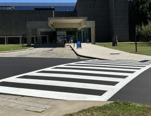
High-Visibility Crosswalks
Most crosswalks are marked with two parallel lines. High-visibility crosswalks use a “ladder-style" pattern that is easier for drivers to see. These markings help make crosswalks and the people using them more visible, especially in areas with a lot of pedestrian activity.
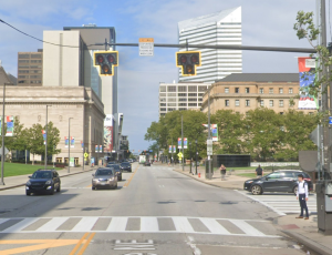
Pedestrian Hybrid Beacon
A Pedestrian Hybrid Beacon (PHB), also known as a HAWK signal, helps people safely cross busy or higher-speed streets. When someone pushes the button to cross, the beacon activates. Drivers first see a flashing yellow light, followed by a solid yellow light, and then a solid red light. Drivers must stop at the red light, allowing pedestrians to cross safely using the walk signal.
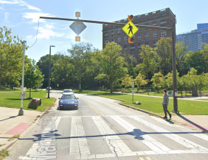
Rectangular Rapid Flashing Beacon
A Rectangular Rapid Flashing Beacon (RRFB) is a pedestrian-activated flashing light that alerts drivers when someone is actively crossing or waiting to cross the street. RRFBs are installed alongside or above a crosswalk to make pedestrians more noticeable and encourage drivers to yield.
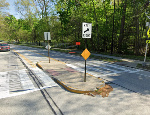
Pedestrian Refuge Island
A pedestrian refuge island is a raised island in the middle of the street that allows people to cross one direction of traffic at a time. It provides a safe place to stop before continuing across the roadway, shortens the crossing distance, and can help slow vehicle speeds. Refuge islands are often installed on streets with a center turn lane or wide roadway.
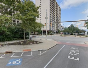
Curb Extension
A curb extension extends the sidewalk into the street at a crossing, making the street feel narrower for drivers. This shortens the distance pedestrians need to cross, improves visibility between people walking and driving, and can encourage drivers to make slower, safer turns.
Project FAQs
This webpage will be updated regularly with Frequently Asked Questions as the project develops.
Winter 2026 → Design complete
Summer 2027 → Construction begins
Fall 2027 → Safety treatments completed
We will continue to update this schedule throughout the project to reflect progress and any changes.
This pedestrian safety project is funded by the following funding sources:
- Ohio Department of Transportation (ODOT) Systemic Safety Funds
- City of Cleveland Vision Zero General Funds
Construction may require temporary lane closures, sidewalk closures, or other short-term changes. The City will provide additional information about construction schedules and traffic impacts as the project moves forward.
Email Sign-Up & Comment Form
Please use the form below to sign up to stay informed with project updates by email and/or submit a comment regarding this project.