Wade Park Avenue
The City of Cleveland and partners are looking to make improvements to Wade Park Avenue between E. 66th Street and E. 118th Street to address traffic safety concerns, improve the condition of the roadway, and strengthen connections in our growing citywide bike network.
Why Wade Park?
Over 91% of drivers are traveling over the 25 MPH speed limit on sections of Wade Park Avenue. This project seeks to address this and other traffic safety concerns, while supporting our Vision Zero commitment to end crashes that result in fatal and serious injuries. There were 82 crashes on Wade Park between 2021-2025, with 2 of those crashes causing serious injury.
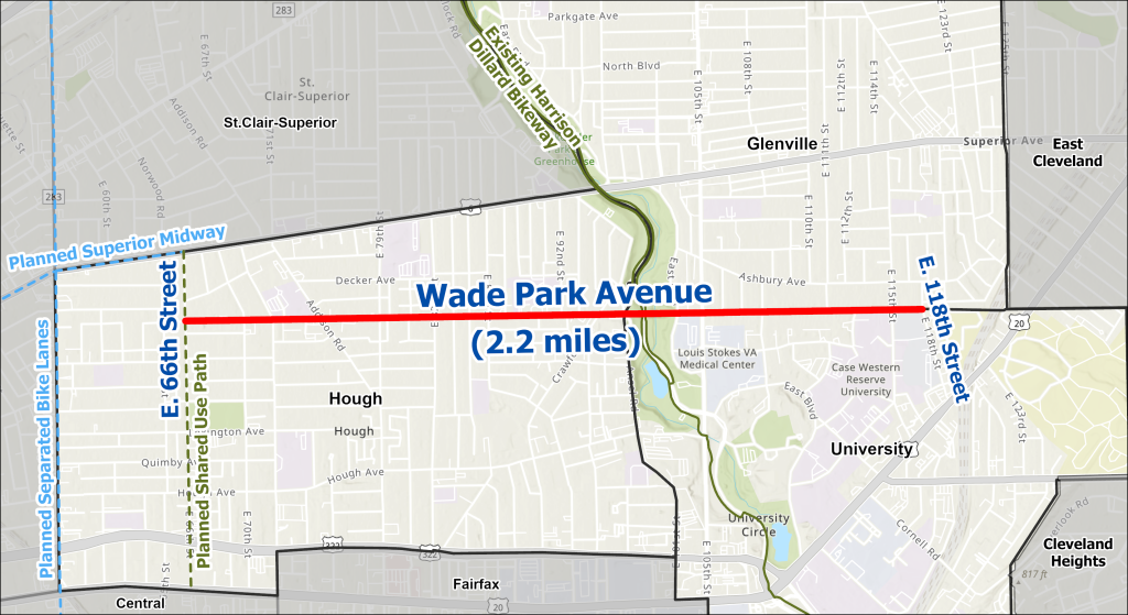
Wade Park is also an important link in the city’s expanding bike network. As shown on the project area map below, separated bike lanes on Wade Park will connect to a planned shared-use path on East 66th Street. That route will then connect to the Superior Midway, bike lanes on East 55th Street, the lakefront, and other destinations. You can learn more about our bikeway vision network on our Cleveland Moves webpage.
View the Project Area Fact Sheet View the Crash Data Fact Sheet
Project Area Map:
Project Goals
Through this project, we hope to accomplish the following:
- Repave the street
- Upgrade curb ramps and replace broken sidewalks
- Reduce speeding by replacing overnight parking lanes with separated bike lanes
- Reduce crashes by replacing several traffic signals with mini roundabouts
- Add new crosswalks in key locations
- Add shade and reduce urban heat island effects by adding street trees and other greening
Design Concept
The conceptual design for Wade Park Avenue includes features such as roundabouts, mini-roundabouts, separated bike lanes, added greenery and street trees, and other improvements to make the street safer and more welcoming.
This design would:
- Move traffic safely and more efficiently by replacing some traffic lights with roundabouts. Between 2021-2025, there were 82 crashes on Wade Park Avenue. Over 75% happened at intersections. Roundabouts have reduced crashes by 60-80% at other intersections in Cleveland.
- Make better use of unused street space. Much of the parking lane is restricted or rarely used. This extra space makes the road feel wide and can lead to speeding and unsafe passing. Adding separated bike lanes would narrow the road, slow traffic, and create a key bike connection on the east side.
- Support all ways of getting around. About one in four Cleveland households do not have a car. Many people rely on walking, biking, or the bus. This plan would create a calmer, repaved street for drivers while adding bike lanes, better crossings, new sidewalks, and more green space.
- Keep the street’s residential character. Wade Park is a family-oriented, residential street. These changes will help reduce speeding and discourage cut-through traffic.
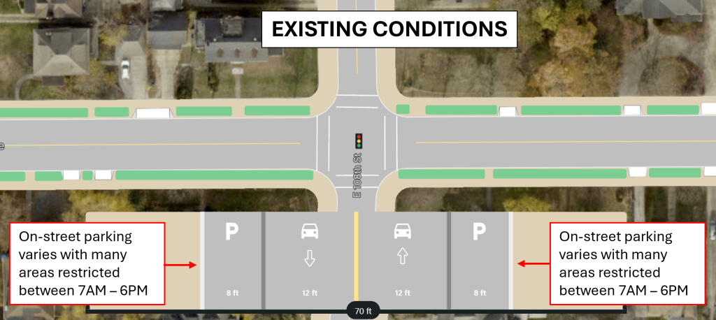
Existing Conditions: The image below shows the existing conditions for the majority of Wade Park Avenue. This includes a single drive lane in each direction and on-street parking, which is time-restricted throughout most of the project area.
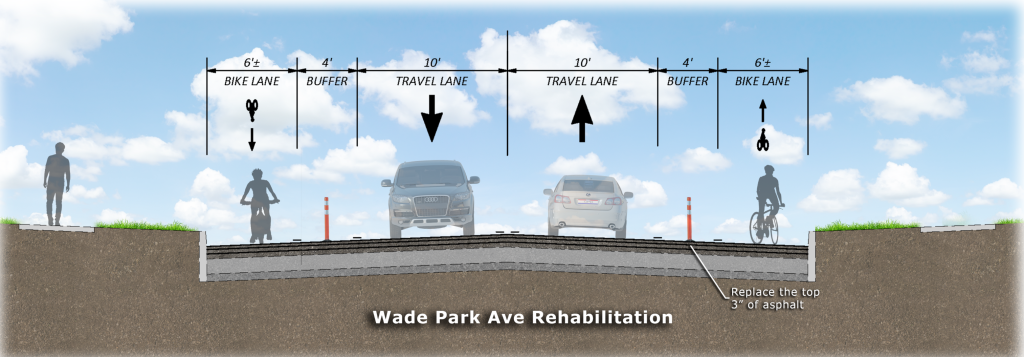
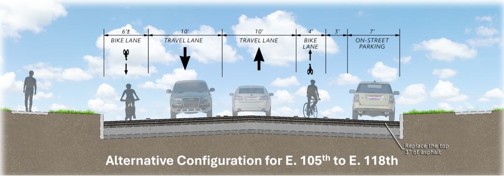
Design Concept: The image below shows the current design concept for the majority of Wade Park Avenue. This includes maintaining a single drive lane in each direction and introducing separated bike lanes. An alternative configuration that maintains curbside parking on one side of the street is being considered between E. 105th Street and E. 118th Street.
Engagement
Throughout 2025 and 2026, we'll be out at community events around Wade Park Avenue to let people know about the project and collect your feedback. Here's a list of events we have attended or will be attending:
| Event | Location | Date | Time |
| Neighbor to Neighbor Community Meeting View the presentation | Tinkham Veale University Center 10038 Bellflower Road Cleveland, OH 44106 | 10/21/25 | 6-7pm |
| Ward 8 Wade Park Avenue Community Meeting | Daniel E Morgan K-8 School 8912 Morris Court Cleveland, OH 44106 | 11/13/25 | 4-5pm |
| University Circle Pedestrian Safety Advisory Meeting | Virtual | 11/24/25 | 4-5pm |
| Neighbor to Neighbor Community Meeting View the presentation | University Circle Inc. 10831 Magnolia Drive Cleveland, OH 44106 | 12/18/25 | 6-8pm |
| Neighbor to Neighbor Community Meeting | CWRU Wade Park Community Engagement Center 11310 Wade Park Avenue Cleveland, OH 44106 | 4/15/26 | 6-8pm |
| Ward 8 Wade Park Avenue Community Meeting View the presentation | Fatima Family Center 6600 Lexington Avenue Cleveland, OH 44103 | 4/16/26 | 5:30- 7:30pm |
| This list will be updated regularly with our event schedule. | |||
Project FAQs
This webpage will be updated regularly with Frequently Asked Questions as the project develops.
- Design begins: Spring 2025
- Design completion: Fall 2026
- Construction contractor selection (bidding process): Spring 2027
- Construction begins: Spring/Summer 2027
- Construction complete: Summer 2028
We will continue to update this schedule throughout the project to reflect progress and any changes.
The Wade Park Avenue project is funded by the following funding sources:
- Northeast Ohio Areawide Coordinating Agency (NOACA) Surface Transportation Block Grant Program (STGB) Federal Funds
- Ohio Department of Transportation (ODOT) Safety Solicitation Funds
- Ohio Public Works Commission (OPWC) State Infrastructure funds
- City of Cleveland Road and Bridge Bonds & Public Utility Funds
Roundabouts are an alternative to a traditional intersection. The most common justification for a roundabout is safety. This is because roundabouts only have 8 potential conflict points compared to 32 at a traditional intersection.
Studies by the Federal Highway Administration (FHWA) show that when roundabouts replace a traffic signal, there is a 48% reduction in total crashes and nearly 80% drop in serious injury and deadly crashes.
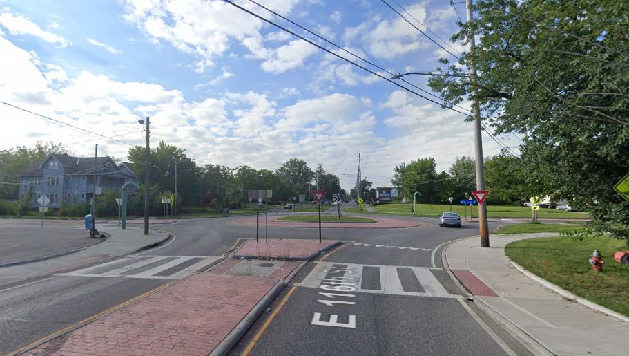
On Wade Park Avenue, the most crash type is angle crashes at intersections (also referred to as a T-bone crash). Roundabouts are a proven measure to prevent these types of crashes. A roundabout is currently being proposed at the Ansel Road intersection.
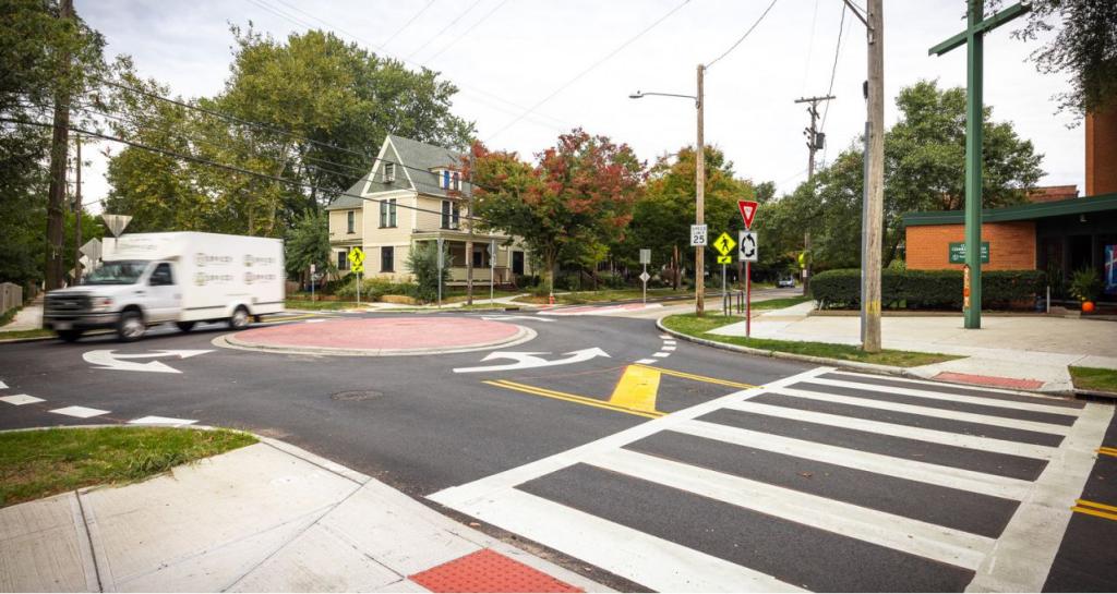
Mini-roundabouts provide the same safety benefits as a regular-sized roundabout at intersections where space is constrained. Mini-roundabouts are often designed with a mountable central island so that larger vehicles (such as trucks and shuttles) can easily and safely travel through the intersection.
On Wade Park Avenue, the most common crash type is angle crashes at intersections (also referred to as a T-bone crash). Roundabouts are a proven measure to prevent these types of crashes. Mini-roundabouts are currently being proposed at the intersections of E. 71st, E. 82nd, East Blvd, E. 108th, and E. 115th.
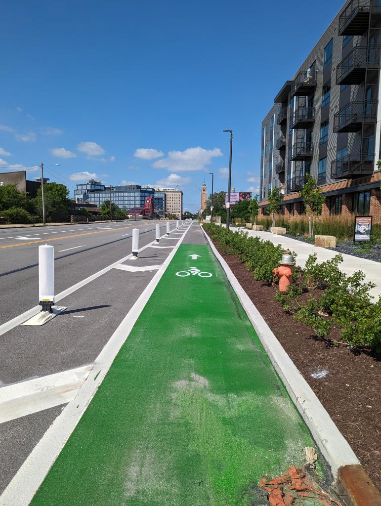
Separated bike lanes make the street safer for everyone using it, no matter how they travel. Physical separation increases comfort for people on bikes and on the sidewalk. It also visually narrows the road for drivers which leads to slower, safer vehicle travel speeds. We can use different materials to physically separate bike lanes, including plastic flexible delineators and concrete curb or jersey barriers.
Separated bike lanes are proven to improve safety for everyone on the road, not just bike riders. Separated bike lanes:
- Reduce average maximum vehicle speed by 28%
- Reduce crashes for all modes by 30-50%
Wade Park Avenue currently has no bicycle facilities. Many sections of Wade Park are wider than necessary, which encourages drivers to speed above the 25 mph speed limit. A traffic count collected on Wade Park near E. 107th Street recorded an average speed of 29 mph and 85th percentile speed of 34 mph. These speeds are considerably fast for a largely residential street.
Email Sign-Up and Comment Form
We want to hear from you! Use the form below to share your thoughts or questions and sign up to stay informed with project updates by email.