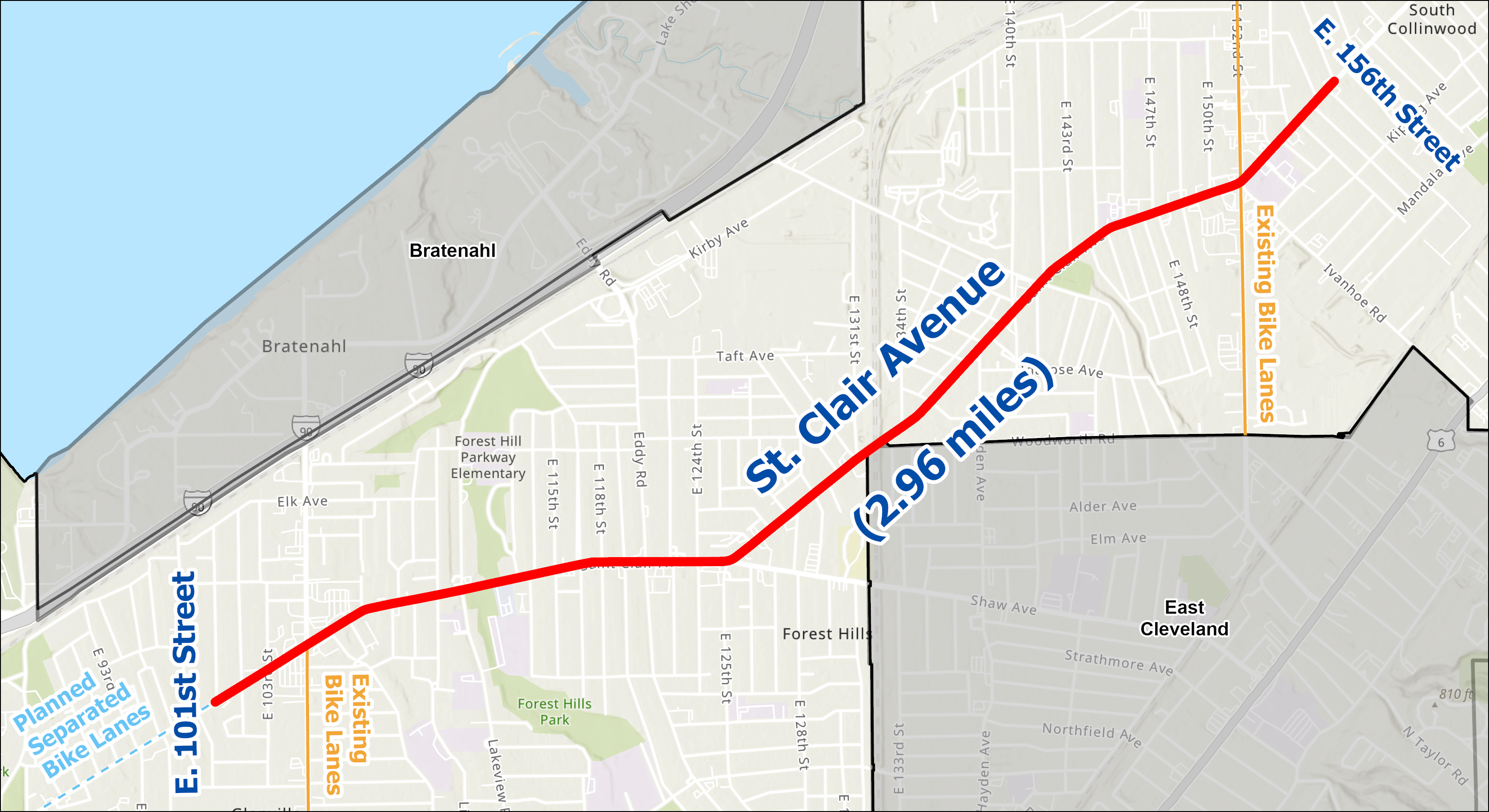
St. Clair Avenue (E.101 to E. 156 Street)
St. Clair Avenue consistently ranks among our most dangerous streets citywide and statewide for traffic safety. We're working to improve safety on St. Clair.
Why St. Clair?
From 2020-2024, at least 14 people were killed and 79 were seriously injured between East 55th Street and East 156th Street. Many neighbors mentioned St. Clair as the most dangerous street in their neighborhood during the Cleveland Moves planning process. Changing the design of the street can reduce dangerous driving behaviors like speeding that lead to crashes.
St. Clair is also a key connection in our growing bike network for many northeast side neighborhoods. Separated bike lanes on St. Clair will eventually connect to separated bike lanes on East 55th Street, which will connect to the lakefront, the Superior Midway, the East 66th Street shared use path, and more.
Project Scope
In line with our commitment to Vision Zero, we are working to end crashes that result in fatal and serious injuries. This project is rooted in safety. This project will:
- Prioritize safety and accessibility for all
- Design the street for safe vehicle speeds, using traffic calming tools including:
- A road diet, which will reduce the number of vehicle lanes and add a center turn lane
- Intersection changes at high crash locations. This stretch of road includes the #1 and #2 most deadly intersections for traffic crashes in Cleveland.
- Pedestrian infrastructure like raised crosswalks and pedestrian refuge islands
- Separated bike lanes
- Bus boarding islands
Draft Design
We are working to design and implement safety tools proven to reduce the types of crashes seen on St. Clair. You can review the conceptual plans below.
Studies show us that a "road diet", where we remove extra vehicle lanes, can reduce crashes by 19-47%. Fewer crashes means our neighbors can safely travel to where they need to go.
Separated bike lanes provide a horizontal buffer and vertical barriers between vehicles and people riding bikes or using the sidewalk. They are proven to improve safety for everyone on the road, not just bike riders. Separated bike lanes:
- Reduce average maximum vehicle speed by 28%
- Reduce crashes for all modes by 30-50%
View the Conceptual Design (PDF)
Learn more about street safety tools in our Street Safety Toolkit
Email Sign-Up and Comment Form
We want to hear from you! Use the form below to share your thoughts or questions and sign up to stay informed with project updates by email.
Updates
We began detailed design for St. Clair Avenue from E 101st to E 156th Street in fall of 2025. We will share updates on this page as we advance the design and hold in-person opportunities to share your thoughts.
We adopted Cleveland Moves in 2025. Cleveland Moves is our citywide transportation plan, required by our Complete and Green Streets Ordinance. We spoke with Clevelanders all over the City about their experiences to guide the planning process. People expressed concerns about dangerous driving and speeding, and asked for solutions to make streets safer. Many constituents also asked for high comfort bikeways that provide separation between vehicles and people riding bikes or using the sidewalk.
The plan also created a bikeway network that prioritizes connecting neighborhoods and high comfort facilities. Explore the map below to see how bike lanes on St. Clair will connect to separated bike lanes on East 55th Street, which will connect to the Mandel Trail, Superior Midway, Payne Avenue separated bike lanes, and more.
We were awarded $2.1 million in U.S. Department of Transportation Safe Streets and Roads for All funds to demonstrate a road diet on St. Clair.
We were awarded an additional $5 million in funds from the Ohio Department of Transportation to implement the results of our safety study. The funds, part of the Target Speed pilot program, prioritize achieving safe speed through roadway design on high crash corridors.
In 2022, we finalized our Vision Zero Action Plan, committing to end serious and fatal injuries from traffic crashes in Cleveland. Through the Vision Zero planning process, we analyzed crash data citywide to understand where crashes happen. The dashboard below ranks our corridors with the highest number of crashes over the last ten years. Six consecutive one mile corridors from St. Clair Avenue are highlighted on this map.
We worked with the Ohio Department of Transportation to conduct a Formal Safety Study for St. Clair Avenue between E 101st and E 156th Street. The study looked closely at crash patterns, speeds, traffic volumes, and potential safety measures that could be installed.