In Summer 2022, we launched a residential speed table pilot to inform a future citywide traffic calming policy. Following successful evaluation of the pilot in May 2023, City Council allocated funding from the American Rescue Plan to expand speed tables and speed humps citywide as part of Mayor Bibb's Back to Basics initiative. We will continue to install additional speed tables in 2025 and 2026, funded by both ARPA funds and City Council discretionary dollars.
Residents may submit location requests to be considered for future speed tables using the form at the bottom of this page.
Speed Table Installation
After piloting 10 speed tables around the city in 2022, we installed the first 100 speed tables of our citywide traffic calming program in 2024. The interactive map below displays the specific speed table locations that have been installed. The map will be updated on an ongoing basis as additional locations are confirmed for 2025 and 2026.
The speed table program currently targets primarily local streets with medium traffic volumes (1,000 to 4,000 vehicles per day) and documented speeding issues (average speeds near or above 25 miles per hour, and 85th percentile speeds near or above 31 miles per hour). The program also prioritizes locations with crash history or the presence of schools, parks, or other areas with high pedestrian volumes. New in 2025, we are also prioritizing streets that are recently repaved.
Citywide map of traffic speed data
What is traffic calming?
Traffic calming refers to street design solutions that slow vehicle speeds, making streets safer for all road users.
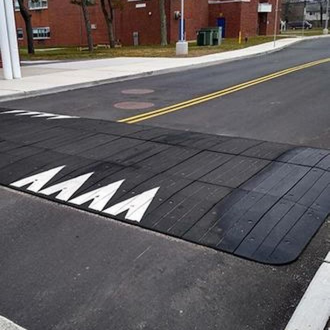
Speed tables are vertical bumps in the road that cause drivers to slow down to drive over them. Speed tables are flat on the top and are not as abrupt as speed bumps, which are narrower and rounded.
Speed humps are vertical bumps in the road that cause drivers to slow down to drive over them. Speed humps are not as abrupt as speed bumps, which are narrower and rounded.
Radar speed feedback signs are posted near speed limit signs and show the travel speeds of passing vehicles to increase drivers' attention and awareness.
Traffic Calming Goals
- Increase quality of life for residents by creating safer, calmer streets.
- Reduce the chance of serious injury or death if a crash does happen.
- Expand local experience with street design interventions that reinforce lower speeds in residential areas.
- Inform citywide traffic calming programs and guidance in alignment with the Vision Zero Cleveland initiative.
Frequently Asked Questions
Although the speed tables will be made of asphalt, they are not installed by the same equipment that resurfaces streets, so they cannot be installed at the same time as resurfacing. However, we are now coordinating speed table installation on qualifying streets that meet eligibility criteria following resurfacing.
Residents can submit locations where they are concerned about speeding to the online form at the bottom of this page. The City will collect data at requested locations to understand vehicle volumes and speeds. This data allows us to prioritize streets for installation.
Speed tables do not impact on-street parking availability. People can still park along the curb in areas with speed tables.
Many cities with significant snowfall have speed tables and other vertical elements in the roadway to slow vehicle speeds. Each speed table is installed with a sign nearby that says "Speed Table". When a snow plow driver sees this sign, they know to expect a speed table and can lift their plow.
2022 Speed Table Pilot
In 2022 we piloted speed tables in various locations around the city. The neighborhood speed table pilot targeted local, primarily residential streets with medium traffic volumes and documented speeding issues. Eligibility was determined by:
- Average daily traffic of 1,000 to 4,000 vehicles
- Average speeds at or above the posted speed limit (>25 mph)
- 85th percentile speeds at 6 mph or over the posted speed limit (31 mph)
Additional prioritization factors included documented crash history and presence of schools, parks, or other bicyclist/pedestrian demand generators.
Pilot Objectives
- Use removable, modular rubber speed tables at nine locations across the city to document the impact of speed tables on vehicle speeds.
- Investigate the feasibility, cost, and effectiveness of a City-installed asphalt speed hump at one location.
- Address any service delivery challenges experienced by Public Safety, Public Works, or Greater Cleveland Regional Transit Authority.
- Document the effectiveness of radar speed feedback signs in addressing residential speeding.
- Collect resident feedback to inform a citywide approach.
Pilot Locations
- Edgewater Drive between W. 117th and W. 115th
- West 101st Street between Madison Avenue and N Marginal Drive
- West 56th Street between Denison Avenue and Eichorn Avenue
- West 50th Street between Kouba Avenue and Clark Avenue
- Bohn Road between East 40th Street and Kennard Road
- Dickens Avenue between Larry Doby Way and East 116th Street
- Corlett Avenue between East 120th Street and East 127th Street
- East 147th Street between Bartlett Avenue and Glendale Avenue
- Judson Drive between East 151st Street and East 160th Street
- East 174th Street between Ozark Avenue and Nottingham Road
Pilot Timeline
- June, 2022: Announce program to the public; place equipment orders.
- August, 2022: Equipment is delivered and installed.
- October, 2022: The City begins post-data collection, including speeds and traffic volumes, service provider input, and community input.
- November, 2022: Snow plow operators are trained and winter data collection begins.
- May, 2023: Pilot evaluation report released.
Speed Table Pilot Evaluation
In May 2023, the City completed its assessment of the 2022 speed table pilot. Across the ten test sites, average speeds fell by 7.8 miles per hour, and over 77 percent of survey respondents expressed support for an expanded speed table program in Cleveland. More information is available via the Cleveland Neighborhood Traffic Calming StoryMap, including traffic data and community comments collected to date, and the Speed Table Pilot Evaluation Report, which outlines key findings and recommendations for future speed table installations.
| Lower volume local streets in 7 pilot locations received 10.5' wide speed tables, with a target design speed of 15 miles per hour. | Neighborhood collectors in two pilot locations (including one along a transit route) received 14' wide speed tables, with a target design speed of 20 miles per hour. |
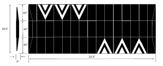 | 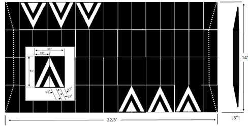 |
Image Credit: Traffic Logix
Share your traffic calming comments
Contact Us
Please use the form above to submit a location to be considered for traffic calming. For additional questions, you can contact us at speedtables@clevelandohio.gov.